Yeah, I'm thinking that ain't happening. First off is the Weather Underground 10 day forecast for Cape Canaveral:
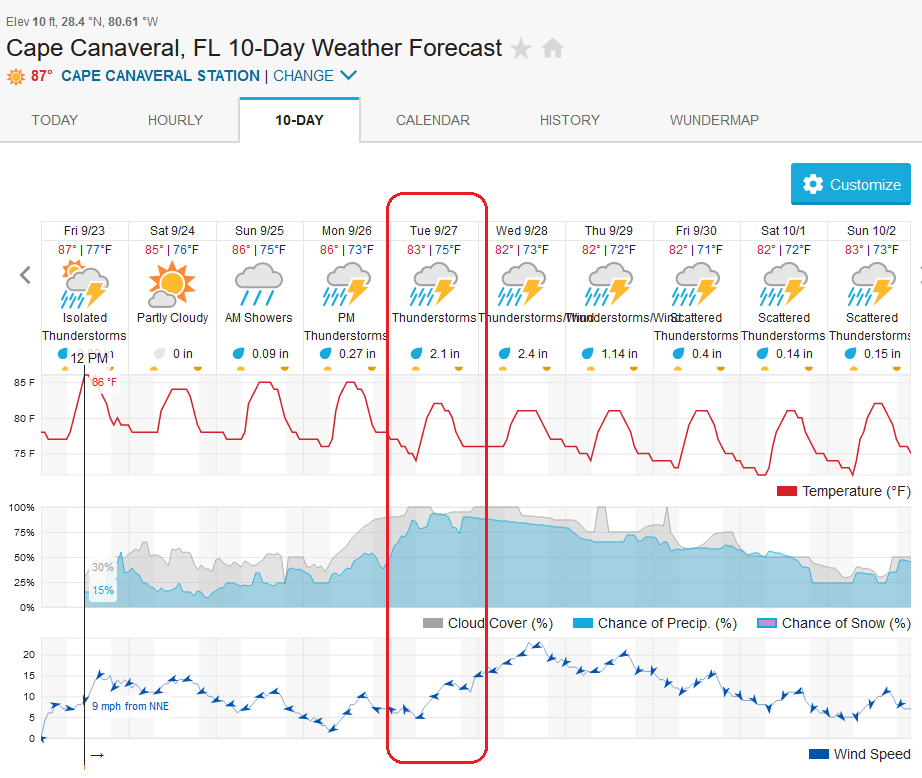
That's Tuesday's penciled-in launch (scroll down that page) highlighted in red - chances of rain over 90% almost all afternoon.
Around the time I made up that graphic, the National Hurricane Center posted this one.

It just became a tropical depression, yet they have it forecast as a Category 3 or higher "Major hurricane" at landfall on the gulf coast by Wednesday morning. In the forecast image above, you can see the winds peaking Wednesday afternoon, but well short of tropical storm, let alone hurricane strength. Borrowing the graphic of Artemis launch windows from a month or so ago:

It seems if we assume Tuesday is out that (unless they have to roll back to the VAB) Friday through Tuesday 10/4 could be available. (Refresher: Red = no go; dark green = longer missions; light green = shorter missions) There were rules for the amount of delay required during the last attempts to launch, which (IIRC) were the second attempt could occur 24 hours after a scrub but the third attempt had to be 48 hours after the second scrub. Something like that.
For the majority of you who don't spend a few weeks every year following these forecasts, let me add that the first three days are shown in white because of the expectation that this is the limit of a forecast that can be depended on. The stippled area is even more of a WAG (Wild-Assed Guess) - expect it to move like a flag in the wind. Even in the white forecast cone, the exact path is expected to wander and the storm is just expected to be somewhere in the white area; there are maps on the NHC website that don't include the center of the forecast path. The white cone here is significantly wider than the one for Fiona, even days ago, meaning there's more uncertainty in this prediction than there was for Fiona. In general weaker storms (invest areas, depressions, tropical storms) are harder to predict than when they become stronger.
I'd be less than surprised to see that landfall prediction move around quite a bit over the next few days.
The storm is going to mess up the launch. I have a friend that lives in Marathon key and he called to see if he could stay at my Condo for the next couple of weeks. He has a 28' Cobia that he will be dragging behind his truck and his wife will be driving their RV loaded with their valuables to get away from the storm. They will be traveling 8 hours north to Crescent Beach just south of St. Augustine. It works for me as I will get a week of fishing as payback sometime in the next year. The Cobia is his retirement job as a charter fishing business and it is the tail end of his slow season.
ReplyDeleteMy buddy arrived in Crescent Beach last night. With the new path he is headed towards Ft Lauderdale tomorrow morning to weather out the storm. My fishing trip has dropped to just a day. :(
DeleteOkay, NASA - take the hint and rollback to the VAB and get those FTS batteries replaced, already. God has spoken - are you listening??
ReplyDeleteMy money says that this is exactly what they will do. They even get good publicity out of it.
DeleteAfter reading the forecast discussion for Tropical Depression Nine, I believe that Igor is spot on. Path is rather uncertain this far out with the storm in the early stages, but the sea surface temperatures and available moisture indicate that whichever way it moves it will very likely be a strong one. The lack of prior activity has created a very unstable air mass for it to take advantage of.
ReplyDeleteNo problem, your forecast graphic predicts a max wind speed of 15 mph, and the direction arrow isn't spinning CCW. Just launch Artemis through the eye.
ReplyDeleteI hope you can keep track of wind speeds reported by offshore buoys like I remember you doing before, for I forget which storm. You proved that storm at landfall was being reported in TV with an exaggerated wind speed.